
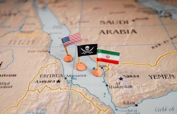
Control of a chokepoint is rarely about planting a flag; it is about acquiring enough reach to compel others’ behavior. With Houthi forces advancing down Yemen’s Red Sea coast to Dhubab and Perim (Mayyun) Island, they now sit astride the Bab al-Mandab Strait’s southern gate—compressing global shipping options while edging within rapid strike range of the multinational military hub in Djibouti across the water.
At a Glance
- Houthi fighters pushed along Yemen’s western coast, seizing Mocha and reaching Dhubab and Perim Island in the middle of Bab al-Mandab, according to multiple outlets citing Yemeni government sources and international wires.
- The movement now exerts coercive leverage over one of the world’s busiest sea lanes; even intermittent disruption at Bab al-Mandab can reverberate through oil flows and container shipping.
- Djibouti—host to Camp Lemonnier (U.S.), and French, Chinese, Japanese, and Italian facilities—sits just across the strait, making allied logistics and surveillance powerful yet exposed.
- The strategic effect does not require permanent “control” of every shoreline; credible strike options, sensors, and selective interdiction can create de facto sea denial at acceptable cost.
What the Houthi advance changed at the chokepoint
Reporting from international wires and regional outlets converges on the same operational picture: after taking Mocha, Houthi units continued south to Dhubab and reached Perim Island, the small but decisive landmass in the middle of Bab al-Mandab that bifurcates eastbound and westbound channels. That geography matters. Perim shortens sensor-to-target timelines and supports the pairing of shore-based missiles, drones, and small boats with spotters who can cue shots into tightly packed sea lanes. The advance did not just lengthen a front; it moved the Houthi fire complex to where global traffic cannot route around it. International assessments and trackers have since framed this as a material shift in leverage over the strait and its approaches.
The mechanism of leverage is familiar to naval strategists. Chokepoints amplify the value of stand-off weapons and cheap attrition systems because ships have little sea room to maneuver, and defenders can mass ISR—intelligence, surveillance, reconnaissance—on predictable tracks. The Houthis have demonstrated a toolkit designed for this battlespace: one-way attack drones, anti-ship missiles, explosive uncrewed surface vessels, sea mines, and coastal radars tied to external intelligence support. You do not need uncontested dominion to affect outcomes; you need enough credible threat to force insurers, shippers, and navies to adjust behavior. That threshold has been crossed before in this theater and can be crossed again quickly when launch corridors move closer to the lanes.
Why Djibouti’s complex military ecosystem is both an asset and a risk
Look 28 kilometers across the water and you find the Horn of Africa’s most consequential military cluster. Djibouti hosts the United States at Camp Lemonnier—Washington’s only permanent base in Africa—alongside French forces, Japan’s first postwar overseas base, Italy’s facility, and China’s first overseas naval base at Doraleh. That concentration underwrites persistent ISR coverage, maritime patrol, special operations reach, and logistics for Red Sea and Gulf of Aden operations. It is also the forward mounting point for quick-turn air and naval responses should shipping in Bab al-Mandab be threatened at scale.
But the same proximity that enables rapid response also compresses warning timelines. Djibouti’s bases and port infrastructure are inside the engagement envelope of the Houthi strike complex now staged along the Yemeni coast. In practical terms, that means base commanders and insurers price in the risk that drones or missiles—launched from nearer coasts or islands—could attempt to hold critical aprons, fuel farms, or harbor facilities at risk. It does not follow that those strikes would succeed against layered air defenses and active patrols, but the mere requirement to posture for them consumes attention and resources, and that is part of the Houthi theory of coercion: impose cost and create decision friction at a chokepoint where disruption scales globally.
How we got here: from harassment to structured sea denial
The Houthi maritime playbook evolved in visible stages. During prior crises, their attacks pushed traffic patterns away from normal Red Sea transits, demonstrating an ability to degrade route reliability without holding every coastal feature. In parallel, the movement refined multi-domain targeting—combining coastal radar, commercial AIS data, drone spotters, and external advisory support—into a more coherent kill chain. As units moved down the coast toward Mocha and Dhubab and onto Perim, that kill chain shortened; launchers and loitering munitions could be staged closer to predictable traffic and naval screens.
Strategically, the advance also intersects with a broader oil and logistics geometry. When Gulf routes are stressed, energy and container lines rely more heavily on the Suez-Bab al-Mandab corridor. Even temporary interruptions at Bab al-Mandab therefore ripple through refinery runs, charter rates, and insurance premia. Analysts and trackers routinely cite the strait among the top three maritime arteries by systemic importance, behind Hormuz and Malacca, precisely because viable alternatives are long, expensive, and capacity-limited.
What “control” really means at Bab al-Mandab
In fast-moving conflicts, the verbs—reached, captured, took over—tend to run ahead of stable front lines. Here, the better frame is effect: can a force consistently threaten and sometimes interdict maritime traffic and nearby infrastructure at acceptable risk and cost? Multiple analyses conclude the Houthis can, particularly when they occupy coastal nodes like Mocha and Dhubab and operate from Perim’s vicinity, even if sovereignty on paper or contested ground shifts day to day. That is why shipping disruptions and military postures change long before any actor achieves textbook “full control” of the strait.
This distinction matters for policy. If the problem set is coercive leverage, not permanent occupation, then effective countermeasures emphasize degrading sensors, launch platforms, and C2—command and control—along the littoral; hardening ships and ports; and maintaining enough naval and air presence to keep the threat below the threshold where insurers and operators pull out. That logic also argues for persistent ISR from Djibouti and allied decks, rapid interdiction of resupply corridors, and quiet diplomacy with coastal actors who control adjacent airspace and waters.
The lightning quick Houthi advances have created a dilemma for the US as it transitions from global to regional hegemon.
The Houthis are now less than 100 miles from Camp Lemonnier, in Djibouti. That's similar to the distance from Iran to Bahrain, where the Iranians pounded
1/— Labrador Skeptic (@SaysSimulation) September 12, 2026
Implications for the next phase
Three consequences follow from the Houthi push to Bab al-Mandab’s mouth. First, shippers and insurers will continue to treat the southern Red Sea as a risk-adjusted corridor, toggling routes and rates in response to attack tempo rather than legal maps. Second, Djibouti’s military ecosystem will remain indispensable to maritime security—its ISR and logistics functions are not easily replaced—but will also require sustained hardening and coordination across national commands to stay ahead of the compressed threat envelope. Third, any durable reduction in risk will come from degrading the Houthi kill chain along the coast and on the islands, not from abstract debates over who “controls” the strait. Geography is fixed; leverage is not.
Sources:
redstate.com, france24.com, theguardian.com, africa.businessinsider.com, hornreview.org, csis.org, washingtoninstitute.org