

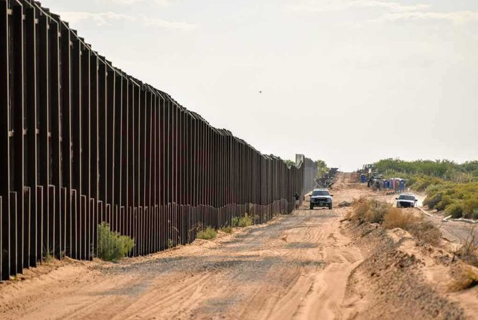
The fight over building a modern border barrier across a Native Nation’s land ultimately turns on a century-old legal instrument: a 60‑foot federal strip set aside in 1907 that the government contends still exists, still belongs to the United States, and still authorizes border infrastructure independent of later tribal boundary claims.
At a Glance
- A 1907 presidential proclamation reserved a 60‑foot swath along the U.S.–Mexico boundary as federal land for border purposes; the Department of Justice argues this “Roosevelt Reservation” remains distinct from later tribal reservations.
- In current litigation over a 62‑mile project across the Tohono O’odham Nation, a federal judge declined to halt construction, crediting the 1907 reservation as a legal basis to proceed while the case continues.
- The Nation argues the wall would take tribal land, shrink its reservation, and harm sacred sites, framing the dispute as one of sovereignty and cultural protection rather than mere right‑of‑way.
- The determinative question is cadastral: does the proposed alignment sit wholly within the 60‑foot federal strip, and how does that strip interact with the Nation’s subsequently established reservation?
What the Roosevelt Reservation Is—and What It Is Not
In 1907, President Theodore Roosevelt issued a proclamation reserving from the public land laws all public lands “within sixty feet of the international boundary between the United States and the Republic of Mexico,” setting them apart “as a public reservation.” The text also directed that this strip be kept free from obstruction. In modern parlance, practitioners call this the “Roosevelt Reservation.” The operative point is ownership and jurisdiction: land lawfully reserved in 1907 for federal border purposes sits in a legal category distinct from later tribal or private claims that may lie immediately north of it.
That distinction is the backbone of the government’s present litigation theory. The Department of Justice argues the Roosevelt Reservation is a federal reservation that predates and survives the later establishment of the Tohono O’odham Nation’s current reservation, and therefore can lawfully host border infrastructure without changing the boundaries of the tribal reservation. In the government’s telling, the question is not whether a wall may be built “on tribal land,” but whether the planned alignment occupies a federal strip that has always been set aside for precisely this class of border-security use.
How This Legal Theory Is Being Applied Today
The present case arose when the Tohono O’odham Nation sued to block construction of approximately 62 miles of barrier where the Nation’s southern boundary meets Mexico, alleging trespass, unlawful diminishment of reservation boundaries, and injury to cultural and environmental resources. The government’s response, relying on the 1907 proclamation, maintains that construction occurs on federal land within the Roosevelt Reservation and thus does not encroach on the reservation’s legal boundary. In an early ruling on a request for preliminary relief, the district court declined to halt construction, crediting the continued legal force of the Roosevelt Reservation as a threshold basis to proceed while the merits are litigated.
Two caveats matter for readers who want the law, not the headlines. First, the 1907 proclamation does not use the words “wall” or “fence”; it reserves a strip and requires it to remain free of obstruction, a formulation that has historically been read to facilitate federal border infrastructure and patrol operations. Second, preliminary rulings are not final merits decisions. They turn on likelihood-of-success assessments and the balance of equities; they can, and sometimes do, narrow as the case develops. The lodestar remains the parcel-level map: if, segment by segment, the barrier sits within the 60‑foot strip, the government’s position strengthens; if any segment strays beyond that federal sliver, the Nation’s encroachment claims gain traction.
The Cadastral Core: Boundaries, Surveys, and Alignment
Border law controversies often become debates about sovereignty and security in public discourse, but inside the courthouse they are resolved by surveys, plats, and chains of title. The 1907 reservation is measured from the international boundary northward sixty feet. That sounds simple; it is not. Riverine segments, monument relocations, historical resurveys, and later land actions complicate where, on the ground, the 60‑foot swath actually lies relative to today’s fence centerline, maintenance roads, and ancillary features such as gates and lighting. The Nation’s complaint highlights this by targeting a 62‑mile project described broadly “across the Nation’s Reservation,” while the legal question requires a foot-by-foot determination of whether each planned structure remains within the federally reserved strip.
Federal documentation and prior barrier programs have repeatedly referenced the Roosevelt Reservation as the preferred envelope for new construction because it reduces the need for takings and easements. Government accountability reporting has also treated the strip as a foundational land base for barrier systems in Arizona, California, and New Mexico. That base-rate practice does not answer the only question that matters here—precise overlap on the Nation’s boundary—but it explains why agencies view the 1907 proclamation as a ready legal pathway when the topography and title records align.
What the Court Has, and Has Not, Decided So Far
According to contemporaneous reporting and filings, the district court accepted the Roosevelt Reservation as a valid source of federal authority and, on that basis, refused to enjoin construction at the preliminary stage. The reporting quotes the court’s reliance on the 1907 proclamation and frames the ruling as a legal win for the government’s continuity theory: the federal strip exists, persists, and can host a barrier without itself diminishing the adjacent reservation boundary. Readers should keep the procedural posture in view: the ruling allows work to proceed while factual development continues; it does not foreclose later disputes over particular segments, cultural-resource compliance, or the interaction with other statutes.
That posture matters because the parties are litigating more than title. The Nation alleges harms to sacred and archaeological sites and frames the project as a violation of its sovereignty and stewardship obligations, not just an encroachment on lines in a plat book. Those claims—cultural, environmental, ceremonial—can run in parallel to the land‑status question. A project can be on federal land and still run afoul of substantive protections if the government has not complied with governing procedures or has chosen a design that inflicts avoidable damage.
Where the Genuine Disagreement Lies
There is little dispute that the Roosevelt Reservation exists as a matter of historical law—indeed, even tribal resolutions describe the 1907 action and label the strip the “Roosevelt Reservation.” The contest is about scope and consequence: does the federal strip overlap every mile of the proposed alignment, and does construction within that strip alter, in law or in practice, the Nation’s reservation boundary or use of adjacent lands? The government’s filing says no to both; the reservation is antecedent federal land, and building within it neither takes tribal land nor shrinks the boundary. The Nation’s lawsuit says yes, in effect, because the wall’s footprint, construction activity, and associated infrastructure will occur on lands the Nation regards as its own and will impede access, water, and cultural practices.
On the evidentiary scale, the government currently carries the stronger position on the narrow title question—anchored by the proclamation’s text and a judge’s refusal to enjoin—while the Nation’s assertions of cultural harm and practical diminishment are weighty but require either factual overlap beyond the 60‑foot line or separate statutory hooks. The decisive proofs have yet to be fully ventilated in public: a segment‑by‑segment cadastral map tying fence centerlines, work pads, and patrol roads to the 60‑foot boundary; and an environmental and cultural‑resource record showing how alternatives were weighed, how sacred sites were avoided, or why avoidance was not possible.
Implications Beyond This Case
The Roosevelt Reservation is not a loophole discovered in 2026; it is a structural feature of federal border governance that has been invoked across administrations to concentrate border infrastructure inside a narrow federal envelope precisely to avoid serial takings battles. When it overlaps tribal boundaries, the legal analysis is stable but the politics and equities are not. Tribes experience walls, blasting, and restricted access as present-tense harms to living communities and sacred landscapes. Agencies experience the same projects as execution of a century-old border mandate within a long‑reserved federal sliver. Those narratives can collide even when the map favors the government.
The practical lesson for policymakers is clear. Where the Roosevelt Reservation is to be used on or near Indian Country, three disciplines are non-negotiable if conflict is to be reduced and litigation risk managed: cadastral transparency that shows the alignment inside the 60‑foot strip; rigorous cultural‑resource surveys and consultation that begin early and continue through design; and design choices—gates, setbacks within the strip, construction windows—that demonstrate respect for sacred sites while retaining border functionality. The proclamation may answer the who‑owns‑what question. It does not answer how to build wisely.
Sources:
nypost.com, tolc-nsn.org, courthousenews.com, tonation-nsn.gov, yahoo.com, govinfo.gov